Uncover Your Property Boundaries: Expert Boundary Survey Tips
Owning a home or property is a big deal. Knowing your land’s exact boundaries is key for legal reasons and keeping your property in good shape.
Most people think they know their property lines. But, they often don’t have solid proof or know how to accurately determine their property lines.
A property boundary survey is a way to find out exactly where your property ends. It helps you know what’s yours.
Knowing how the boundary survey process works and using the right tools can help you manage your property better.
Key Takeaways
- Understanding the importance of knowing your property boundaries.
- Learning the basics of a property boundary survey.
- Identifying the right surveying tools needed.
- Recognizing the role of a boundary survey in property management.
- Discovering expert tips for conducting a boundary survey.
Understanding Property Boundary Surveys
Boundary surveys are key to managing your property. They find and mark your property’s exact lines, corners, and boundaries. This is called a cadastral or property survey.
What Is a Boundary Survey?
A boundary survey sets your property’s exact limits. It checks property deeds, historical records, and physical markers. This is vital for new owners, developers, or those planning land changes.
Why Boundary Surveys Matter
Boundary surveys are important for avoiding neighbor disputes and following land rules. They also clarify who owns what. Accurate surveys boost property value by defining property lines clearly, which is key for selling or buying.
Types of Property Surveys
There are many property surveys, like boundary, topographic, and subdivision surveys. Each has its own purpose, from setting property lines to mapping the land’s shape and dividing it.
| Survey Type | Purpose | Key Features |
|---|---|---|
| Boundary Survey | Determine property lines and corners | Accurate boundary marking, compliance with regulations |
| Topographic Survey | Map the terrain and features of the land | Detailed topography, natural and man-made features |
| Subdivision Survey | Divide land into smaller parcels | Creation of new property lines, compliance with local regulations |

Knowing about different property surveys helps owners make smart decisions. Accurate boundary surveys prevent disputes and increase property value.
Legal Aspects of Property Boundaries
Property boundaries are more than just lines on the ground. They carry legal weight. Knowing this can help avoid disputes and protect your rights.
Property Deed Analysis
Start by analyzing your property deed. It outlines your property’s boundaries and any rules or easements. Reviewing it carefully is key to understanding your legal rights.
Easements and Encroachments
Easements and encroachments can impact your property. An easement lets someone use part of your land for a specific reason. An encroachment happens when someone builds on your land without permission. It’s important to know about these to protect your property.

Legal Requirements by State
Legal rules for property surveys vary by state. It’s important to know what your state requires. Some states need a survey for property sales, while others don’t. Knowing your state’s rules helps you follow the process correctly.
When Surveys Become Legally Binding
A boundary survey can become a legal document if it’s properly documented and agreed upon. The surveyor will create a boundary survey report that details the findings. Once everyone agrees, the report can help settle disputes in the future.
In summary, understanding property boundaries’ legal side is key. By analyzing deeds, knowing about easements and encroachments, and following state laws, you can safeguard your property. This helps avoid legal problems.
Professional vs. DIY: What You Need to Know
Property owners often face a choice between hiring a professional or doing it themselves. A boundary survey is key to knowing your land’s limits. The choice you make can greatly affect the outcome.
When to Hire a Professional Surveyor
For complex property issues, a professional surveyor is best. If you’re looking for a “boundary surveyor near me,” pick a licensed expert. This ensures your survey is valid.
Benefits of DIY Boundary Surveys
DIY surveys can save money for simple property checks. But, they come with risks and limitations. An accurate DIY survey needs precise measurements and detailed records.
| Survey Type | Cost | Accuracy |
|---|---|---|
| Professional Survey | High | High |
| DIY Survey | Low | Variable |
Limitations of Self-Surveying
DIY surveys have their downsides. Without the right training and tools, accuracy can suffer.
Legal Validity of DIY Surveys
DIY surveys might not hold up in court. For a residential boundary survey to be legally valid, a professional is usually needed.
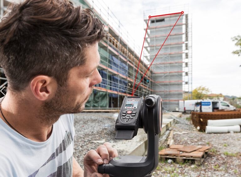
Essential Surveying Tools Needed for Boundary Surveys
Boundary surveying uses many tools, from simple to advanced. Licensed land surveyors use these tools to measure and map property lines. They often mark boundaries and create detailed maps.
Basic Measurement Tools
Basic tools are key for boundary surveys. They give the first data needed to find property lines.
Measuring Tapes and Wheels
Measuring tapes and wheels are basic but crucial. They help measure distances between points.
Compasses and Levels
Compasses find directions and orientations. Levels make sure measurements are straight, which is important for accuracy.
Advanced Surveying Equipment
Advanced tools make boundary surveys more precise and efficient. They’re great for complex properties or when high accuracy is needed.
Total Stations and Theodolites
Total stations and theodolites measure angles and distances. They’re very accurate and versatile.
Laser Measuring Devices
Laser devices give quick and accurate distance measurements. They’re often used with other tools.
Digital Tools and Software
Digital tools and software have changed boundary surveying. They improve accuracy, reduce manual work, and enhance data analysis.
GPS Devices
GPS devices use satellite signals for precise locations. They’re very useful for boundary surveys, especially in hard-to-reach areas.
Mapping Applications
Mapping apps and software help create detailed maps and analyze data. They work with other tools for complete boundary surveys.
| Tool Category | Examples | Use in Boundary Surveys |
|---|---|---|
| Basic Measurement Tools | Measuring Tapes, Wheels, Compasses, Levels | Initial measurements, determining directions and levels |
| Advanced Surveying Equipment | Total Stations, Theodolites, Laser Measuring Devices | Precise angle and distance measurements |
| Digital Tools and Software | GPS Devices, Mapping Applications | Precise location determination, data analysis, and mapping |
How to Do a Boundary Survey: Step-by-Step Process
To ensure accuracy, it’s essential to follow a step-by-step process when conducting a boundary survey. This process involves several critical stages that help in determining and marking a property’s legal boundaries.
Gathering Property Documents
The first step in conducting a boundary survey is gathering all relevant property documents. This includes the property deed, any existing survey reports, and other legal documents related to the property. Reviewing these documents carefully helps in understanding the property’s legal description and identifying any potential issues.
Identifying Initial Reference Points
Once the documents are gathered, the next step is to identify initial reference points. These are typically found in the property deed or previous survey reports and serve as the starting point for measuring the property boundaries. It’s crucial to verify these reference points for accuracy.
Measuring and Marking Boundaries
With the reference points identified, the next step involves measuring and marking the property boundaries. This requires the use of surveying tools and techniques to ensure accuracy. Precision is key in this stage to avoid any discrepancies.
Here’s a simple table outlining the basic steps and tools used in measuring and marking boundaries:
| Step | Tools Used | Purpose |
|---|---|---|
| 1. Measure Distances | Tape measure, GPS device | Determine boundary lengths |
| 2. Mark Boundaries | Survey markers, paint | Physically mark property lines |
| 3. Verify Measurements | Surveying software | Ensure accuracy and compliance |
Triangulation Techniques
Triangulation is a method used to determine the location of a point by measuring the angles and sides of triangles formed by reference points. This technique is particularly useful in boundary surveys for establishing precise locations of boundary markers.
Documenting Your Findings
The final step in the boundary survey process is documenting your findings. This involves creating a detailed report that includes the survey data, measurements, and any observations made during the survey. Accurate documentation is essential for legal purposes and future reference.
By following these steps, property owners can ensure that their boundary survey is conducted accurately and effectively. This helps prevent potential disputes and ensures that their property rights are protected.
How to Survey Your Own Property Effectively
To survey your own property well, start with thorough research. Knowing your property boundaries is more than just where your land ends. It’s about understanding your rights and duties as a property owner.
Preliminary Research Steps
Before you go out to survey, take some important research steps. This ensures your survey is accurate and effective.
Obtaining Official Records
First, get official records about your property. This includes your property deed, any survey reports, and other documents from your local government. These can tell you a lot about your property’s boundaries, easements, and any encroachments.
Consulting Neighboring Properties
Talking to your neighbors and looking at their property records is also smart. It can help spot boundary disputes early. Being open with your neighbors can avoid misunderstandings and make surveying easier.
Field Work Techniques
After getting the right info, it’s time for the field work. This means physically measuring and marking your property’s boundaries.
Setting Up Baseline Measurements
Begin by setting up baseline measurements. This means finding known points on your property and using them to find other boundary points. Using accurate measurement tools is key here.
Marking Property Corners
Once you’ve found your boundary points, mark them clearly. Use stakes, flags, or other markers. Make sure these markers are strong and easy to see to avoid them getting lost or damaged.
Common DIY Surveying Mistakes to Avoid
Surveying your own property can be rewarding, but there are common mistakes to steer clear of:
- Inaccurate measurements: Use calibrated equipment and double-check your measurements.
- Ignoring local regulations: Learn about local surveying laws and regulations.
- Not documenting your findings: Keep detailed records of your survey process and results.
By avoiding these mistakes and following the steps above, you can effectively survey your own property. If unsure about any part of the process, consider getting help from a professional surveyor for accuracy and to follow local laws.
Modern Technology in Boundary Surveying
Modern technology has changed boundary surveying for the better. It brings more accuracy and speed. Old methods are now mixed with new tech for better results.
Drone Surveying Applications
Drones are changing boundary surveying. They can cover big areas fast and take clear pictures. This makes surveying cheaper and faster, helping everyone involved.
LiDAR and 3D Mapping
LiDAR and 3D mapping are making surveys more precise. They create detailed models of the land. This helps in drawing accurate boundaries and cuts down on disputes.
Mobile Apps for Property Owners
Now, there are apps for property owners to do simple surveys. These apps aren’t a full replacement but help understand boundaries.
Future Trends in Property Surveying
The future of boundary surveying looks bright. Advances in AI, machine learning, and drones will make it even better. We’ll see more accurate and efficient surveys.
Handling Boundary Disputes and Discrepancies
Boundary disputes can start from misunderstandings or disagreements over property lines. These often lead to legal fights between neighbors. A boundary survey can help solve these problems by clearly showing property lines.
### Identifying Potential Boundary Issues
Looking at property documents and doing a land survey can find potential issues. Differences between recorded and actual boundaries can cause problems like encroachments or land use disputes.
Talking openly with neighbors is key to solving boundary disputes peacefully. This can lead to understanding and compromise, avoiding expensive legal fights.
It’s important to know your property boundaries well, as shown by a professional survey.### Legal Remedies for Boundary Disputes
If talking doesn’t work, legal steps might be needed. Knowing the laws about property boundaries and disputes is crucial. This includes when a survey can be used in court.
“A boundary survey is not just a tool for the surveyor; it’s a legal document that protects property rights.”
### When to Seek Mediation
Mediation is a good option when talking directly doesn’t work. A mediator can help both sides find a fair solution without going to court.
- Mediation is a less confrontational way to solve disputes.
- It involves a neutral third party.
- It’s cheaper than going to court.
Conclusion: Securing Your Property Boundaries
Knowing and protecting your property lines is more than just following the law. It’s a way to keep your property safe. A professional boundary survey gives you clear information about your property’s edges. This is key for any building or fixing up plans.
This knowledge lets you use your property to its fullest. It also helps you avoid legal issues and follow the rules for property surveys. Knowing all of this, and the cost of the Surveying Equipment and Tools needed, you may see how inexpensive it is to hire a professional surveyor to perform your boundary survey. Not only do they have the expensive instruments, but they are also experienced and qualified to uncover potential issues with your survey and provide you with a stamped plat of survey from a Licensed PLS (Professional Land Surveyor).