Essential Land Surveyor Equipment: What You Need to Know
Land surveying is a key profession that has been important for centuries. It helps determine property boundaries and supports civil engineering projects. It also plays a role in managing land development.
This work involves complex tasks that need precision and accuracy. It relies on the right surveying instruments and essential survey tools.
Important land surveyor equipment includes surveying tripods, GNSS equipment, and total stations. These tools are key to getting accurate measurements and reliable data.
Key Takeaways
- Land surveying is crucial for property boundary determination and civil engineering projects.
- The right equipment is essential for accurate measurements and reliable data.
- Surveying tripods, GNSS equipment, and total stations are among the key tools used.
- Precision and accuracy are paramount in land surveying.
- Modern land surveying relies on advanced technology and instruments.
Understanding the Role of Modern Land Surveying
The field of land surveying has changed a lot. It now uses the latest technology for precise land mapping.
Land surveying is about measuring and mapping land. It helps show what a property or area looks like. It’s important for construction projects, solving boundary disputes, and making land transactions smoother.
Today, land surveying uses advanced tech. This makes surveying more accurate and faster. New surveying equipment and methods have changed the field a lot.

Looking at land surveying’s history helps us see how it’s changed. Old methods are now replaced by new ones. These include GNSS (Global Navigation Satellite System) and GPS (Global Positioning System).
| Surveying Technique | Application | Key Equipment |
|---|---|---|
| GNSS Surveying | High-precision positioning | GNSS Receivers |
| GPS Surveying | Navigation and mapping | GPS Receivers |
| Total Station Surveying | Detailed topographic surveys | Total Stations |
Modern land surveying is used in many ways. It helps with urban planning and construction. It’s also used for environmental monitoring and land development. The exactness of modern surveying tech is key in these areas.
What Equipment Does a Land Surveyor Use: A Comprehensive Overview
Land surveyors use many tools to do their jobs well. They need a variety of equipment for tasks like measuring and finding exact locations. This includes everything from basic tools to advanced technology.
They mainly use three types of equipment: tools for measuring, tools for support, and tools for marking. Total stations are key for measuring distances, angles, and heights. They help surveyors get accurate data.
GPS equipment is also very important. It lets surveyors find exact locations and heights by using signals from satellites.
The surveying prism is another must-have. It works with total stations to send signals back, making measurements more accurate.

Here’s a quick look at the main tools land surveyors use and what they do:
| Equipment | Primary Use | Key Features |
|---|---|---|
| Total Stations | Measuring distances, angles, and heights | Electronic theodolite integrated with EDM |
| GPS Receivers | Determining precise locations and heights | Satellite signal reception, high accuracy |
| Surveying Prisms | Reflecting signals for distance measurements | High-quality glass, adjustable mounting |
Knowing how each tool works is key for land surveyors. It helps them make sure their measurements are right and reliable.
Support and Stability Equipment
Support and stability equipment are key in land surveying. They help keep surveying instruments steady, leading to precise measurements.
Surveying Tripods: The Foundation of Accurate Measurements
Surveying tripods are crucial for land surveying. They give a solid base for tools like theodolites and total stations.
Types and Materials of Surveying Tripods
There are many types and materials of surveying tripods. Aluminum is popular because it’s strong and light.
- Aluminum Tripods: Lightweight and durable, ideal for most surveying tasks.
- Wooden Tripods: Less common, but offer stability in certain conditions.
Proper Setup and Maintenance
Setting up and maintaining tripods is key for accurate work. Make sure the tripod is level and stable. Also, check it regularly for wear.
- Ensure the tripod legs are securely positioned.
- Use the leveling mechanism to achieve precise leveling.
- Regularly inspect and maintain the tripod to prevent equipment failure.
Surveying Bipods: When and How to Use Them
Surveying bipods add extra support for instruments. They’re useful when a tripod isn’t practical. They offer more flexibility.

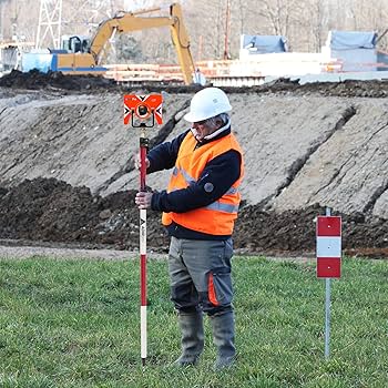
Prism Poles and Their Applications
Prism poles work with total stations and other gear to measure distances and angles. They’re versatile and used in many surveying tasks.
| Equipment | Primary Use | Key Features |
|---|---|---|
| Surveying Tripods | Providing a stable base for surveying instruments | Durable materials, adjustable legs |
| Surveying Bipods | Additional support for instruments in specific situations | Portable, flexible |
| Prism Poles | Measuring distances and angles with total stations | Versatile, compatible with various surveying equipment |
Measurement and Leveling Tools
Measurement and leveling tools are key in land surveying. They help find heights, angles, and distances with great precision.
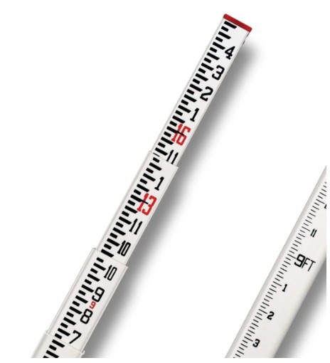
Grade Rods: Essential Vertical Measurement Tools
Grade rods measure vertical differences on the earth’s surface. They come in different materials, each with its own benefits.
Fiberglass vs. Aluminum Grade Rods
Fiberglass grade rods are durable and weather-resistant, perfect for outdoor use. Aluminum grade rods are light and accurate, great for precise projects.
Fiberglass rods stay consistent in measurements, unaffected by temperature changes. Aluminum rods are easy to handle because they’re light.
Builder’s Grade Rods and Story Poles
Builder’s grade rods are for construction, helping with grading and excavation. Story poles measure structure heights, useful in building projects.
“The right grade rod can make all the difference in ensuring the accuracy of your measurements.”
Leveling Instruments: Types and Applications
Leveling instruments find the heights of points on the earth’s surface. There are many types for different surveying needs.
Laser Levels: Modern Precision Technology
Laser levels show a level line or dot, making accurate measurements over long distances. They’re great for big construction projects.
Auto-levels are easy to use and accurate. Transit levels can level and measure angles, making them versatile.
Hand Levels and Abney Levels: Portable Solutions
Hand levels are small and portable, perfect for quick field measurements. Abney levels measure angles and are good for topographic surveys.
Theodolites and Transits: Angle Measurement Specialists
Theodolites measure angles between points with high accuracy. Transits do the same but also level.
Theodolites are known for precise angle measurements. Transits are versatile for many surveying tasks.
Marking and Identification Equipment
Marking and identification equipment are key for land surveying success. They help surveyors mark reference points and boundaries accurately. This is crucial for survey accuracy.
Land Surveying Markers and Rods
Markers and rods are basic tools for survey points. Surveying rods vary in length and are paired with grade rods for height measurements.
Markers include surveyor’s roll flagging and paint. They mark survey points clearly on the ground.
Marking Solutions for Different Terrains
Different terrains need different marking tools. In tough spots, Mag nails and PK nails are used. They’re durable and work on many surfaces.
Surveyor’s Roll Flagging and Marking Paint
Surveyor’s roll flagging works well on many terrains. It’s easy to use and stands out, perfect for open areas.
Marking paint is great for hard surfaces like roads and concrete. It leaves a clear mark.
Mag Nails, PK Nails, and Their Applications
Mag nails and PK nails are made for tough terrains. They’re durable and leave a lasting mark.
Surveyor’s Brush Axes and Property Corner Pin Finders
Surveyor’s brush axes clear vegetation to reveal markers. Property corner pin finders locate buried pins.
These tools are vital for land surveying. They help mark points accurately, even in hard places.
Advanced Digital Surveying Technology
Advanced digital surveying technology is changing how land surveyors work. It has made surveying more precise, efficient, and reliable. Key technologies have made old surveying methods outdated.
GNSS and GPS Equipment: Satellite-Based Precision
GNSS (Global Navigation Satellite System) and GPS (Global Positioning System) equipment are key in modern surveying. They give exact location info and are vital for many survey tasks.
To use GPS, you set up the equipment to get satellite signals. Then, it figures out exact positions. You need to plan well to get the best signal.
GNSS and GPS are very precise but have limits. For example, they can be blocked by trees or buildings. To get better results, use multiple systems and services.
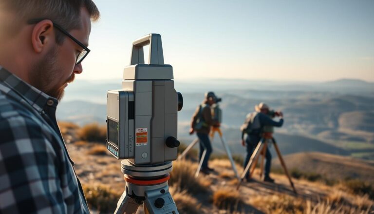
Total Stations: Comprehensive Measurement Solutions
Total stations are electronic/optical tools for measuring distances, angles, and heights. They mix theodolite functions with electronic distance measurement.
Total stations offer detailed measurements by combining angles and distances. They are used for many tasks, from simple to complex surveys.
Magnetic Locators: Finding Hidden Metal Objects
Magnetic locators find hidden metal things like pipes and cables. They are key for finding utilities and avoiding dangers during digging.
Magnetic locators work by finding the magnetic field of the target. This is great when you can’t see the object.
Optical Equipment and Accessories
In land surveying, optical tools are key for getting accurate data. They help take precise measurements, making the surveying work smoother.
Surveying Prisms: Types and Applications
Surveying prisms are vital in optical surveying. They work with total stations to measure distances and angles accurately. Different types of prisms exist, like 360-degree prisms and mini prisms, for various needs.
The right prism depends on the survey task and environment. Mini prisms are great for tight spaces, while 360-degree prisms are flexible for many points.
Tribachs and Land Surveying Adapters
Tribachs and adapters are crucial for land surveying. They make different instruments and tripods work together. Tribachs help secure instruments like total stations on tripods.
Land surveying adapters add to this flexibility. They let you use various instruments with different tripods. This is super useful in complex projects needing many setups.
Specialized Optical Accessories
There are many specialized optical accessories for land surveying. These include optical targets, plumb lines, and eyepiece prisms. Each has a special role in making surveys more accurate and efficient.
Optical targets help mark clear points for measurements. Eyepiece prisms make using some instruments easier, reducing fatigue during long surveys.
Storage and Transportation Solutions
Surveyors need reliable storage and transportation for their equipment. This keeps their gear accurate and long-lasting.
They use bags and cases to protect their equipment. These solutions prevent damage and keep things organized in the field.
Bags and Cases: Protecting Your Surveying Investment
There are many types of bags and cases for surveying equipment. Hard cases are best for sensitive gear like total stations and GNSS receivers. Soft bags are good for carrying accessories and smaller items.
When picking bags and cases, think about durability, weather resistance, and customization. Some brands offer tailored solutions for surveyors.
| Type of Bag/Case | Features | Best for |
|---|---|---|
| Hard Cases | Waterproof, shockproof, customizable interiors | Total Stations, GNSS Receivers |
| Soft Bags | Lightweight, multiple compartments, padded | Accessories, smaller items |
| Backpacks | Ergonomic design, multiple pockets, weather-resistant | Fieldwork, carrying multiple equipment |
Organizing Equipment for Field Efficiency
Keeping surveying equipment organized is crucial for efficient fieldwork. Equipment organizers and pouches help keep gear sorted and easy to find.
For better organization, categorize items by type and use color-coded labels. Make sure often-used items are easy to reach. This saves time and prevents equipment loss or damage.
Equipment Selection Guide for Different Surveying Projects
The type of equipment needed for a surveying project changes a lot. This depends on the project’s scope and the environment it’s in.
Choosing the right equipment is key. It ensures the surveying work is accurate, efficient, and safe.
Residential vs. Commercial Surveying Equipment Needs
Residential and commercial surveying projects need different tools. This is because they have different scopes and complexities.
For homes, surveyors use basic tools like grade rods and leveling instruments. These help them get the accuracy needed.
- GNSS receivers for precise location data
- Total stations for measuring distances and angles
- Surveying software for data analysis and mapping
Commercial projects, on the other hand, need more advanced and strong equipment. This is because they cover larger areas and deal with tougher terrains.
Specialized Equipment for Challenging Environments
Surveying projects often face tough environments. These include dense forests, rugged terrains, or urban canyons. Specialized equipment is needed for these challenges.
- Magnetic locators to detect underground utilities
- Robust total stations that can handle harsh weather
- Advanced GNSS equipment with real-time kinematic (RTK) for better precision
These specialized tools help surveyors overcome the obstacles in difficult environments. They ensure accurate results are delivered.
Conclusion: Building Your Land Surveying Equipment Arsenal
Having a good set of land surveying equipment is key for surveyors to do their job well. As new tech comes out, it’s important to keep up with the latest tools and methods.
A good surveyor’s checklist should have the basics like surveying tripods, leveling tools, and GNSS gear. The right tools help surveyors handle different projects, from homes to big buildings and tough sites.
Surveyors should always check and update their equipment. They need to think about what each project needs and get the newest tech and special tools.
This way, surveyors can give top-notch results, work better, and stay ahead in their field.