Land Surveying in 2030: Staying Relevant in a Changing World
If you think surveyors will still be pounding hubs with sledgehammers in 2030, think again. Drones are in the sky, AI is crunching coordinates, and the ground is shifting – literally and figuratively. Will technology replace you, or will it make you more valuable than ever? Here’s what you need to know to stay ahead of the curve, sharpen your edge, and become the kind of surveyor the future actually needs.
The world of land surveying is on the verge of a big change. New tech and more use of geospatial data are leading the way. Looking ahead to 2030, we see drones, laser scanning, and GPS playing big roles.
The FIG Congress says land surveying is getting more tech-savvy. This makes us wonder: Will robots take over the jobs of land surveyors? The answer is tied to the skills needed to keep up with the times.
To stay ahead, surveyors need to learn new tech skills. They also have to get used to new roles, like the “Survey Technologist.”
Key Takeaways
- The future of land surveying is heavily influenced by technological advancements.
- Emerging tech skills are crucial for surveyors to stay relevant.
- Drones, laser scanning, and GPS are key tools in modern land surveying.
- The role of the “Survey Technologist” is emerging as a new profession.
- Surveyors must adapt to new technologies to remain competitive.
The Evolution of Land Surveying: From Chains to Satellites
The land surveying industry has seen big changes. It moved from old methods to new, high-tech ways. These changes have made surveyors’ work more accurate and efficient.
Historical Perspective on Surveying Methodologies
Long ago, surveyors used chains and tapes for measurements. This method was good for its time but slow and often wrong. The use of theodolites was a big step forward, allowing for better angle measurements.
The Digital Revolution in Modern Surveying
Today, digital technology has changed land surveying a lot. Surveyors now use tools like Global Navigation Satellite Systems (GNSS), LiDAR, and drones. These tools have greatly improved how they collect and analyze data.
Key Technological Milestones
Important milestones include the use of GNSS for precise locations, LiDAR for detailed 3D models, and drones for aerial data. These tools have made surveying faster and more accurate.
These technologies have made surveying easier and opened up new ways to analyze data. As the field keeps growing, using these new tools will be key to staying up-to-date.
Current Challenges Facing the Land Surveying Profession
The land surveying field is at a turning point, facing many challenges. These issues threaten its role in today’s world. It’s vital to tackle these problems head-on to secure a bright future.
Aging Workforce and Knowledge Transfer Issues
The land surveying field is seeing a big change due to an aging workforce. This could lead to a knowledge gap. Knowledge transfer from older to younger surveyors is key to keeping the industry going.
Keeping Pace with Rapid Technological Advancements
New tech like drones and LiDAR technology is changing the game fast. Surveyors need to keep learning to stay up-to-date. This means getting used to new tools and methods.
Economic Pressures and Market Competition
Economic stress and more competition are big hurdles. Surveyors must deal with these while keeping their work top-notch.
By grasping these challenges, the land surveying field can start working on solutions. This will help the industry stay strong and vibrant in 2030 and beyond.
Will Robots Replace Land Surveyors? (Spoiler: You’re Safer Than You Think)
Automation is changing the land surveying world. But, what does this mean for the people working in it? The worry that robots and automation will take over human surveyors is real. Yet, it’s key to grasp the limits and potential of these new technologies.
The Realistic Limits of Automation in Surveying
Automation has advanced a lot in land surveying. But, some parts of the job are hard for tech to do alone. For example, making tough decisions and using professional judgment are key skills that humans have.
Professional judgment is more than just making choices. It’s about knowing the full story and making smart decisions. Humans are great at this because they can handle surprises and use their experience to guide them.
The Irreplaceable Human Element: Professional Judgment
The worth of human surveyors comes from their professional judgment. This is something tech can’t easily copy. Surveyors need to read data, know the law, and make choices that show they really get the project.
Augmentation Rather Than Replacement
Technology is not here to replace surveyors. Instead, it’s making them better and more precise. With tools like drones, GPS, and advanced software, surveyors can do more of what they’re good at. This means they can focus on tasks that need their special skills.
In short, while tech will keep changing land surveying, it won’t replace human surveyors. By knowing what tech can and can’t do, surveyors can keep up with the times.
Land Surveying in 2030: How to Stay Relevant in a Changing World
Looking ahead to 2030, the land surveying world is on the edge of big changes. New technologies and shifting client needs will shape the industry.
Predicted Industry Transformations and Disruptions
The land surveying field will see major shifts, including:
- More use of automation and artificial intelligence
- Higher demand for data analysis and interpretation
- Introduction of new tech like augmented reality and IoT
Surveyors will need to be flexible and ready for new methods and tools.
Core Competencies That Will Remain Essential
Even with changes, some key skills will stay important for surveyors, such as:
- Professional judgment and decision-making
- Good communication and client service
- Ability to understand and analyze complex data
These abilities will still be crucial, as they work alongside the tech advancements.
Adapting to Digital Transformation in Land Surveying
To keep up, surveyors must adopt digital changes, like 3D modeling and BIM integration. The focus will also shift to using data and spatial analysis.
By grasping these shifts and adapting, surveyors can thrive in 2030 and beyond.
Top 3 Emerging Tech Skills Every Surveyor Should Master
To stay ahead in land surveying, surveyors must learn new tech skills. The digital transformation in land surveying brings new chances and challenges. Those who adapt will thrive in a competitive field.
Advanced Data Analysis and Spatial Interpretation
Now, analyzing and understanding complex data is key. Surveyors need to find insights in big datasets and make smart choices. Big data management is a big part of this skill.
Big Data Management for Surveyors
Effective big data management includes several steps:
- Data integration: Merging data from different sources into one place.
- Data processing: Using algorithms and software to work with data.
- Data visualization: Showing complex data in a simple way.
Programming and Geospatial Software Development
Knowing programming languages and geospatial software is crucial. Learning languages like Python or R helps automate tasks and create tools. Innovative practices in land surveying often need custom software.
3D Modeling, BIM Integration, and Visualization
3D modeling and Building Information Modeling (BIM) are becoming more common. They help create detailed, interactive project models. This improves teamwork and decision-making. Visualization tools make complex projects easier to understand.
By learning these top 3 tech skills, surveyors can keep up with the industry’s fast pace. As evolving technology in land surveying grows, the best will be those who innovate and adapt.
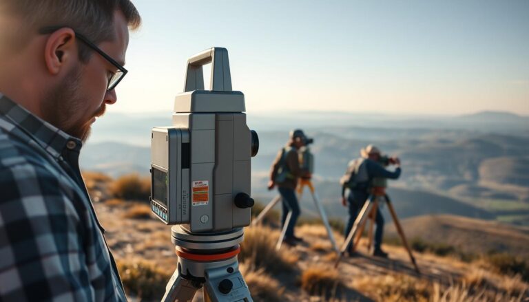
Drones, Laser Scanning, and GPS: Tools That Separate Pros from Amateurs
Professional land surveyors use advanced tools like drones, laser scanning, and GPS. These tools improve surveying accuracy and efficiency. They also change how we do land surveying.

Advanced Drone Applications and Regulations
Drones are key in land surveying, doing more than just taking pictures. They help with topographic surveys, tracking construction, and checking infrastructure.
Beyond Basic Aerial Photography
Drones can do orthomosaic mapping and 3D modeling. This gives surveyors detailed data. But, following drone rules is tricky, as they keep changing.
LiDAR and 3D Laser Scanning Techniques
LiDAR and 3D laser scanning change how we collect and analyze data. They make accurate 3D models of landscapes and buildings.
These tools are great for tough surveying jobs. They work well in places with lots of plants or tall buildings.
Next-Generation GPS and Positioning Systems
New GPS and positioning systems offer centimeter-level accuracy. This is a big step up from old GPS.
Centimeter-Level Accuracy Challenges
Getting to centimeter-level accuracy is hard. It faces problems like signal interference and weather effects. New GPS methods, like Real-Time Kinematic (RTK) positioning, help solve these issues.
By using these new technologies, land surveyors can offer top-notch services. They meet their clients’ needs and stay up-to-date in their field.
The Rise of the “Survey Technologist”: A New Role for a New Era
The future of land surveying is changing with the “survey technologist” role. This person connects surveying with IT. As tech advances, this role is becoming key.
Defining the Survey Technologist Position
A survey technologist mixes surveying skills with IT knowledge. They use GPS, drones, and geospatial software. They handle complex data, making them crucial in today’s surveying.
Required Qualifications and Career Pathways
To be a survey technologist, you need surveying or IT background and extra training. You might start as a technician and move up with experience and education in programming and data analysis. Getting certified and keeping up with new tech is also important.
Bridging Traditional Surveying and Information Technology
The survey technologist links old surveying methods with new IT. They use LiDAR, 3D modeling, and spatial analysis for better services. This mix makes surveying more efficient and opens new doors for innovation.
In summary, the survey technologist marks a big change in land surveying. They bridge the old and the new. As the field evolves, the need for these experts will likely increase, shaping the future of surveying.
Artificial Intelligence and Machine Learning in Land Surveying
Artificial intelligence and machine learning are changing land surveying. They make it more efficient and accurate. These technologies help surveyors work with data in new ways.
Automated Feature Extraction and Classification
AI and ML help with automated feature extraction and classification. They use algorithms to spot and sort features from big datasets. Automated feature extraction lets surveyors quickly find things like buildings and roads. This saves time and boosts productivity.
Machine learning models learn from big datasets. They pick up on patterns and characteristics. Then, they can apply this knowledge to new data, finding important information fast and accurately.
Predictive Analysis for Land Development
AI and ML are also used for predictive analysis in land development. They look at past data and trends to predict future changes. This helps surveyors and developers plan better, using land wisely and protecting the environment.
- Predicting land use changes based on historical trends
- Assessing environmental impacts of development projects
- Optimizing infrastructure planning
AI-Assisted Quality Control and Error Detection
AI and ML are also key in quality control and error detection. They check survey data for mistakes, making sure it’s right. This makes survey data better and saves time and money.
Using AI-assisted quality control helps surveying firms be more accurate. This makes them stand out in the market.
Innovative Practices in Land Surveying: Case Studies from Early Adopters
Innovative practices are changing the land surveying industry. Many case studies show how new technologies and methods are helping firms. They are now more efficient, delivering better results and staying competitive.

Success Stories of Firms Embracing Technological Change
Many firms have added new practices to their work. For example, using drones for aerial surveying has sped up and improved their work. This has cut down on time and money spent on projects.
- Improved accuracy and reduced errors
- Enhanced efficiency and productivity
- Increased safety for surveyors
Also, firms using advanced data analysis and spatial interpretation techniques give clients better insights. This helps them stand out in the market.
Lessons Learned from Implementation Challenges
Firms have faced challenges when adopting new practices. They needed to spend a lot on technology and training. But, those who started early have learned important lessons.
- Assessing the right technology for specific needs
- Investing in comprehensive training for staff
- Phased implementation to mitigate risks
Measurable ROI from Innovative Approaches
The benefits of new practices in land surveying are clear. Firms have saved a lot of money, finished projects faster, and made clients happier. These gains help justify the cost of new technologies and methods.
For instance, a firm using drones saved 30% on costs and finished projects 25% faster. These results show the worth of adopting new practices in land surveying.
Adapting Education and Training for Future Surveyors
Educational institutions and professional groups are changing how they train the next land surveyors. The field is growing with new tech and changing needs. So, it’s key to have education that’s adaptable and forward-thinking.
Evolving Curriculum Requirements for Surveying Programs
Surveying courses now include drones, GIS, and BIM. They should mix theory with hands-on use of new tools and software.
Continuing Education and Professional Development
It’s important for pros to keep up with land surveying’s latest. Groups and schools need to work together for good, affordable learning. This could be through workshops, online classes, and certifications.
Balancing Technical Skills with Professional Judgment
Technical skills are important, but so is professional judgment and ethics. Schools should teach critical thinking and problem-solving. This way, future surveyors can handle complex situations well.
Business Models and Service Offerings for 2030
The future of land surveying is not just about new tech. It’s also about changing business models and services. As we move towards 2030, surveyors need to meet new client needs and market changes.
Value-Added Services Beyond Traditional Boundary Work
Land surveyors are now offering value-added services beyond just boundary work. These include:
- Environmental monitoring and assessment
- Construction monitoring and quality control
- GIS mapping and spatial analysis
- Drone-based surveying and inspection services
Specialized Niches and Emerging Market Opportunities
Surveyors are finding specialized niches and new market chances. This helps them stand out and earn more. Examples are:
- Surveying for renewable energy projects
- Providing data for smart city initiatives
- Expertise in land development and urban planning
Subscription and Data-Based Revenue Models
The industry is moving towards subscription and data-based revenue models. Surveyors offer ongoing data access for a fee. This model brings steady income and builds lasting client ties.
By adopting these new models and services, land surveyors can thrive in 2030. They’ll be ready for the future of land surveying and lead in innovative practices in land surveying.
Conclusion: Embracing Change to Thrive in 2030 and Beyond
The future of land surveying is all about adapting to new tech and market needs. We’ve seen big changes coming, like using artificial intelligence and machine learning. There’s also a new role called the “survey technologist.”
To keep up in land surveying, professionals need to be open to these changes. They must learn new skills to succeed in a fast-changing world. This way, they stay ahead and find new chances for growth and creativity.
The industry is changing fast, and those who will do well in 2030 and later are ready to adapt. They are proactive, flexible, and always learning. They keep their skills sharp and their knowledge up to date.